File:NATO partnerships.svg
Jump to navigation
Jump to search


Size of this PNG preview of this SVG file: 800 × 360 pixels. Other resolutions: 320 × 144 pixels | 640 × 288 pixels | 1,024 × 461 pixels | 2,560 × 1,152 pixels.
Original file (SVG file, nominally 800 × 360 pixels, file size: 1.6 MB)
| This is a file from the Wikimedia Commons. The description on its description page there is shown below.
|
Summary
| Description |
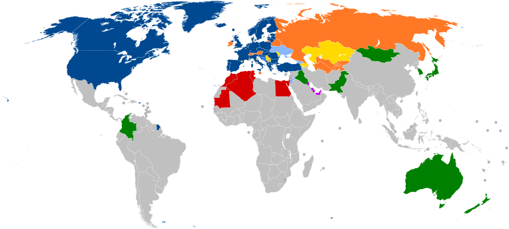
English: A global map of NATO partners around the world (with all the sovereign states that are under 20,000 km2 in area represented by a circle)
NATO member states #3131FC #2A7FFF thin solid transparent #88B7FF thin solid transparent #FFD900 thin solid transparent #FF7826 thin solid transparent #D40000 thin solid transparent #C0F thin solid transparent #008000 thin solid transparent [[:w:NATO Français : Carte montrant les affiliations actuelles des pays européens avec l'OTAN. Les pays de moins de 20000 km2 sont représentés par un cercle.
Membres actuels #3131FC #3584fd #88b7ff #FFD900 thin solid transparent #FF7826 thin solid transparent #D40000 thin solid transparent #C0F thin solid transparent #008000 thin solid transparent Partenariat
Português: Mapa mostrando as afiliações atuais dos países europeus com a OTAN. Os países com menos de 20.000 km2 são representados por um círculo.
Estados-membros da NATO #3131FC #2a7fff #88b7ff #ffd900 #ff7826 #d40000 #cc00ff #008000 Parceiros |
| Date | |
| Source |
This file was derived from: NATO cooperations partners.svg: |
| Author | Patrick |
| Other versions |
Derivative works of this file: Peak positions of Adele's 21 in worldwide charts.svg Derivative works of this file: NATO partnerships - 2.svg |
| SVG development |
Notes
- ↑ Partnership Interoperability Initiative. NATO (22 February 2022). Retrieved on 23 March 2022.
Licensing
I, the copyright holder of this work, hereby publish it under the following license:
This file is licensed under the Creative Commons Attribution-Share Alike 3.0 Unported license.
- You are free:
- to share – to copy, distribute and transmit the work
- to remix – to adapt the work
- Under the following conditions:
- attribution – You must give appropriate credit, provide a link to the license, and indicate if changes were made. You may do so in any reasonable manner, but not in any way that suggests the licensor endorses you or your use.
- share alike – If you remix, transform, or build upon the material, you must distribute your contributions under the same or compatible license as the original.
Original upload log
This image is a derivative work of the following images:
- NATO cooperations partners.svg licensed with Cc-by-sa-3.0
- 2012-02-06T21:37:21Z Patrickneil 800x360 (1681649 Bytes) Kosovo in gray
- 2012-02-06T21:34:07Z Patrickneil 800x360 (1681641 Bytes) Forgot Finland and Sweden
- 2012-02-06T21:26:54Z Patrickneil 800x360 (1692374 Bytes) Darker gray for non-affiliated countries
- 2012-02-06T21:23:31Z Patrickneil 800x360 (1682546 Bytes) trimming some of Micronesia for standard width of 800px
- 2012-02-06T21:11:00Z Patrickneil 842x358 (1688505 Bytes) == {{int:filedesc}} == {{Information |Description={{en|1=A global map of the world, with all the [[:en:List of countries and outlying territories by total area|sovereign states that are under 20,000 km2 in area]] represented
Uploaded with derivativeFX
File history
Click on a date/time to view the file as it appeared at that time.
| Date/Time | Thumbnail | Dimensions | User | Comment | |
|---|---|---|---|---|---|
| current | 16:45, 7 March 2024 | | 800 × 360 (1.6 MB) | wikimediacommons>Janitoalevic | Sweden added |
File usage
There are no pages that use this file.